The River Severn at Shrawardine was once crossed by the Shropshire and Montgomeryshire Light Railway. Nearby, a Second World War ammunition depot connected the railway to the wider Nesscliffe storage complex. The dismantled crossing and the depot are two related parts of the area's history. Railway Heritage Trust ↗; Shropshire HER ↗.
The old railway bridge
Photographs record the crossing before its removal. A Britain from Above aerial image dated 14 January 1948 shows the railway bridge over the flooded Severn near Little Shrawardine Farm. Ken Brockway photographed the bridge on 25 April 1954, during a Railway Correspondence and Travel Society visit. 1948 aerial photograph ↗; Brockway photograph ↗.
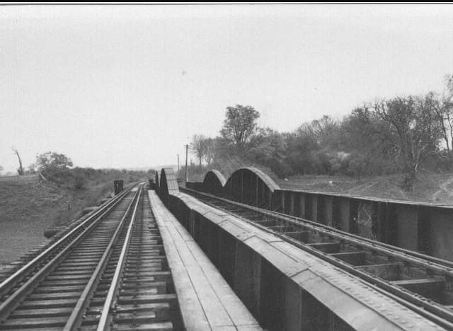 Shrawardine railway bridge, 25 April 1954. Photograph © Ken Brockway, CC BY-SA 2.0.
The bridge's rebuilding history is less clear. Shrewsbury Railway Heritage Trust dates its reconstruction as a single-track viaduct to 1947. A separate Shropshire Railways account describes major repairs by the Royal Engineers towards the end of the war. These accounts may concern different phases of work, but the sequence has not been established. Heritage Trust ↗; Shropshire Railways ↗.
Shrawardine's ammunition depot
The county Historic Environment Record identifies the site as WW2 Ammunition Depot, Pentre, part of Central Ammunition Depot Nesscliffe and connected to the Shropshire and Montgomeryshire railway. Its description places wartime buildings north of Shrawardine, east of the Severn and on both sides of the former railway. Shropshire HER ↗.
Richard Maund's railway chronology dates the formal transfer of train operation to the War Department to 1 June 1941, under No. 1 Railway Group, Royal Engineers. It records extensive military railway layouts at Shrawardine, Pentre and other locations along the line. Maund, p. 12 ↗.
Closure and surviving traces
On 4 May 1960, a government statement in Parliament described Shrawardine as a former ammunition depot. Most of the land was intended for sale, with a small area to be retained for training. This records the government's plans at that date, rather than confirming when any sale took place. Hansard ↗.
Railway closure happened in stages. Maund records withdrawal of the remaining civilian commercial traffic on 29 February 1960, followed by a railtour on 20 March. The War Office relinquished the line on 31 March, with some subsequent movements to recover railway materials. Maund, pp. 14–15 ↗.
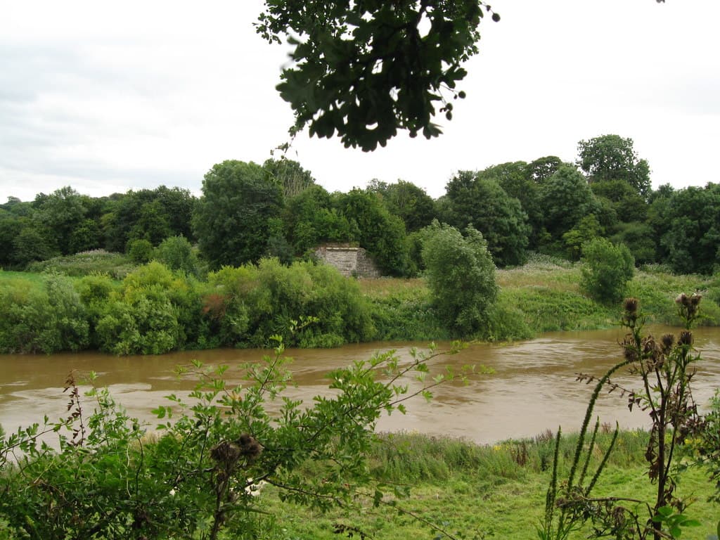
Shrewsbury Railway Heritage Trust dates dismantling of the bridge to 1962. A photograph taken in 2013 records a surviving stone abutment across the river. Heritage Trust ↗; Phelan photograph ↗.
The HER describes apparently surviving wartime buildings, drawing on 2009 aerial photography, and records a further aerial survey in 2018. These observations document surviving features at those dates; they do not establish every building's condition or use today. Shropshire HER ↗.
Swimming hazards and river levels
Submerged bridge foundations: Local information supplied to this guide reports that the old bridge foundations remain in the river and can lie only a few inches below the surface. They pose a hazard to swimmers: take particular care near the former crossing and do not jump or dive into the water here. The depth over the remains varies with river levels.
Source: local information supplied to Shrawardine.com on 18 September 2026; the reported depth has not been independently measured for this guide.
The Environment Agency maintains a flood-warning page for the River Severn at Shrawardine, Montford Bridge and Mytton ↗, with links to nearby river-level readings. Consult that service for current information.
For related village history, see Shrawardine Castle and Shrawardine Millennium Green.
Sources & further reading
- Shropshire Historic Environment Record, WW2 Ammunition Depot, Pentre, PRN 30903 (MSA33700), via Heritage Gateway; updated 3 April 2024. Accessed 18 September 2026. ↗
- UK Parliament, Land, Shrewsbury, House of Commons Hansard, 4 May 1960, vol. 622, cols. 1066–67. Accessed 18 September 2026. ↗
- Richard Maund, Shropshire & Montgomeryshire Light Railway and its predecessors — a chronology from primary and secondary sources, Railway and Canal Historical Society, pp. 12, 14–16. Accessed 18 September 2026. ↗
- Shrewsbury Railway Heritage Trust, Walk along the Old Shropshire and Montgomeryshire Railway, notes for the 16 May 2009 visit, section 5: Shrawardine. Accessed 18 September 2026. ↗
- Shropshire Railways, Shrewsbury to Llanymynech, undated historical account. Accessed 18 September 2026. ↗
- Britain from Above, Railway bridge over a flooded River Severn near Little Shrawardine Farm, Little Shrawardine, EAW012696, 14 January 1948. Accessed 18 September 2026. ↗
- Ken Brockway, Railway Bridge across River Severn (1954, now dismantled), 25 April 1954, Geograph photograph 340064, CC BY-SA 2.0. Accessed 18 September 2026. ↗
- Martin Richard Phelan, Severn viewpoint third view — Shrawardine, Shropshire, 17 August 2013, Geograph photograph 3606822, CC BY-SA 2.0. Accessed 18 September 2026. ↗
- Ordnance Survey, Shropshire sheet 033/NE, catalogued 1883–1895, Wikimedia Commons reproduction sourced from British History Online. Accessed 18 September 2026. ↗
- Environment Agency, River Severn at Shrawardine, Montford Bridge and Mytton flood warning area. Accessed 18 September 2026. ↗